Reality Capture for Digital Transformation

Reality Captured.
Intelligence Engineered.

DARKSKY is an infrastructure intelligence firm. We capture the physical world at engineering precision and convert it into the structured digital intelligence that every consequential decision depends on, across the asset's life.

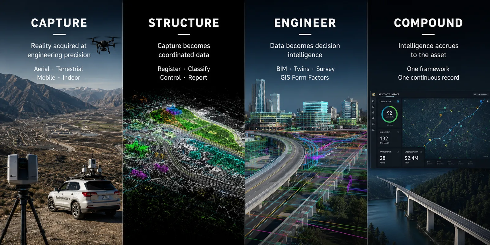
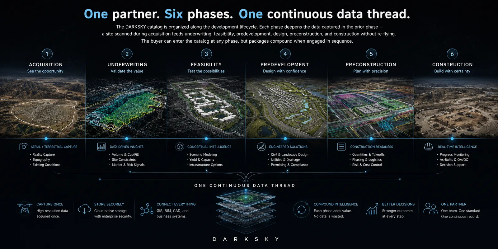
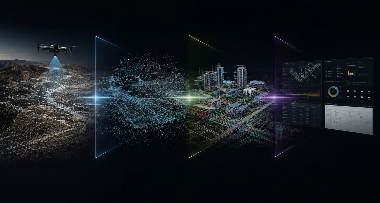
The Industry Problem

Most firms scan for a deliverable. Then they leave.

The reality capture industry was built around single-deliverable engagements. A client asks for a topographic survey, an existing-conditions model, a stockpile report. The capture firm scans for that one thing, delivers it, and moves on. Six months later, the same site is scanned again, for a different deliverable, by a different vendor, from a fresh start. The captured data is treated as a by-product. The archive, if it exists, is a courtesy. The next decision about the same site begins from zero. The duplicate cost is real. The duplicate calendar time is worse. The most expensive number in a development pro forma is the one that comes from a guess; the second-most expensive is the one that comes from a re-scan.

500 acre greenfield project: point cloud and masterplan
$25K–$40K
Typical duplicate capture cost across one development cycle when each phase re-scans.
30–60 days
Iteration time eliminated when feasibility data exists at acquisition.
$200K–$1M+
Budget surprises traceable to a single bad sitework assumption.
The Operating Doctrine

Capture is the foundation. Intelligence is the product.

DARKSKY treats every capture as the first layer of a four-layer intelligence stack, calibrated to engineering precision, structured into coordinated datasets, engineered into the decision intelligence the client actually buys, and stewarded so the asset's intelligence compounds across its entire life. This is not a process diagram. It is the firm's operating logic. Every flight, every scan, every deliverable, every contract clause, every line of code in our pipeline is a downstream consequence of this doctrine.

Intelligence Stack: Capture, Structure, Engineer, Compound
Lifecycle Solutions

One partner. Six phases. One continuous data thread.

The DARKSKY catalog is organized along the development lifecycle. Each phase deepens the data captured in the prior phase. A site scanned during acquisition feeds underwriting, feasibility, predevelopment, design, preconstruction, and construction without re-flying. The buyer can enter the catalog at any phase, but packages compound when engaged in sequence.

Development lifecycle: acquisition, underwriting, feasibility, predevelopment, preconstruction, construction
Full-Spectrum Capture

One partner across the full capture spectrum.

DARKSKY operates the full reality-capture spectrum. Aerial photogrammetry and aerial LiDAR by multirotor and fixed-wing platforms. Terrestrial static LiDAR. Vehicle and backpack mobile mapping. Indoor SLAM. Close-range photogrammetry for detail and facade work. A client with a complex asset does not have to orchestrate three vendors and reconcile three coordinate systems. They engage one firm with one chain of custody, one coordinate system, and one accuracy framework. Where the client's security posture requires American-sovereign capture, we execute with it.

Aerial Reality Capture
Drone photogrammetry, drone LiDAR, fixed-wing UAS, combined-sensor missions. Topographic surfaces, orthomosaics, vegetated terrain, large-area capture.
Terrestrial LiDAR
Tripod-based static laser scanning; close-range photogrammetry; high-detail facade capture. Scan-to-BIM source data, facade dimensional truth.
Mobile & Indoor
Vehicle- and backpack-mounted SLAM, handheld SLAM, 360 imagery for GNSS-denied environments. Plant interiors, corridor mapping.
Digital Engineering
Scan-to-BIM, CAD topographic surfaces, volumetrics, deviation reports, digital twins. Existing-conditions BIM, design base, as-built verification.
GIS Services
Feature extraction, attribution, topology, schema-aligned deliverables, portal publishing. Infrastructure inventory, utility documentation, planning overlays.
Digital Engineering Pipeline

Reality capture is the input. Digital engineering is the asset.

DARKSKY operates a four-stage digital engineering pipeline. Capture is the first stage and the most visible, but it is not the product. Processing converts raw sensor data into engineering-grade captures. Extraction draws CAD, BIM, GIS, and reporting deliverables from those captures. Stewardship is the often-invisible final stage: the documentation, archival, governance, and accuracy reporting that makes every deliverable defensible against professional, lender, insurance, and legal review. The buyer's experience is a single coordinated pipeline. The same dataset feeds the underwriter, the architect, the GC, and the lender, without re-flying, without re-registering, and without the coordinate-system reconciliation tax.

Digital engineering pipeline: capture, process, extract, steward
STAGE 1
Capture
Aerial, terrestrial, mobile, or indoor capture, designed at the density and accuracy the data deserves, not the minimum the immediate deliverable tolerates.
STAGE 2
Processing
Photogrammetric or LiDAR processing produces engineering-grade point clouds, orthomosaics, classified data, and accuracy-reported foundations.
STAGE 3
Extraction
CAD surfaces, BIM elements, GIS features, digital twins, volumetric reports, and progress overlays are extracted from the processed dataset.
STAGE 4
Stewardship
The dataset is documented, archived, and governed so it can serve future deliverables and survive professional review.
Accuracy & Defensibility

Engineering-grade defensibility is our baseline, not our premium tier.

Every DARKSKY deliverable is produced to one of three accuracy tiers. The tier is declared in the scope of work, governs methodology, and maps to an ASPRS 2024 accuracy class. Documented procedures, traceable accuracy, independent QA, FGDC-compliant metadata, and licensed Professional Land Surveyor or Professional Engineer oversight on Tier P deliverables are how we run, not how we respond when a client asks. A DARKSKY deliverable is built to survive professional review, insurance review, lender review, and legal review without scrambling to produce documentation after the fact. The accuracy report is the product, not just documentation.

TIER R
Relative · Reconnaissance
≤ 25 cm RMSE
Screening, visualization, conceptual analysis, IC flyovers, deal triage.
Sign-off: DARKSKY QA
TIER A
Absolute · Engineering-Grade
≤ 7 cm RMSE
Underwriting, design support, construction monitoring, defensible measurements.
Sign-off: DARKSKY QA
TIER P
Precision · PLS/PE-Stamped
≤ 3 cm RMSE
Design base, financing conditions, legal-grade evidence, dispute defense.
Sign-off: Licensed PLS or PE seal
Industries

Built for the buyers who govern the asset.

DARKSKY serves the institutional real estate development ecosystem and the AEC firms that build for it. Our buyer gravity is on the owner and capital side (developers, REITs, capital partners, lenders, owner's representatives) because the data we produce most directly governs decisions about money, risk, and time. Our parallel channel is the AEC services ecosystem (architects, engineers, general contractors, specialty trades) who pull DARKSKY into their projects and become channel partners over time. Both channels run from day one.

ICP-1
Real Estate Developers
Compress the cost of being right about a site.
SiteIQ · DealRisk · GradeSmart · ConceptTwin · ProgressPulse
ICP-2
REITs & Portfolio Owners
Capture the portfolio once. Steward the record forever.
DealRisk · TwinBuild · CloseoutPack · recurring recapture
ICP-3
General Contractors
Bid, verify, and defend against documented reality.
BaselineSnapshot · BidSharp · ProgressPulse · EarthTrack · CloseoutPack
ICP-4
Architecture & Engineering
Anchor the design in reality, not in as-drawns.
PremiumTopo · Scan2BIM · FacadeExact · FlowState
ICP-5
Industrial & Energy
Document the plant without slowing it down.
Scan2BIM · FacadeExact · ClashProof · recurring as-built capture
ICP-6
Capital Partners & Lenders
Verify what's funded. Defend what's drawn.
DealRisk · TitleGuard · RiskLock · PayAppProof · ProgressPulse
ICP-7
Title Companies & Counsel
Reconcile physical reality with the legal record.
TitleGuard · BaselineSnapshot · DelayDefense
ICP-8
Municipal & Infrastructure
Sovereign-capable capture for public-sector assets.
GIS deliverables · infrastructure inventory · sovereign-capable platforms
Technology Stack

Technology-forward. Hardware-agnostic. Sovereign-capable.

DARKSKY's stack is organized in four layers: capture hardware, processing software, deliverable authoring, and business and delivery infrastructure. We are not dogmatic about hardware. We fly and operate the best tool for the job — but we are prepared to meet the sovereignty requirement that an increasing number of public-sector, utility, and critical-infrastructure clients now carry.

Intelligence flows up · Data flows down

Business Infrastructure

  • Secure Delivery
  • Doc Control
  • CRM
  • Project Mgmt
  • QA/QC

Deliverable Authoring

  • AutoCAD Civil 3D
  • Revit
  • Navisworks
  • ArcGIS Pro
  • FME

Processing Software

  • Pix4D
  • Metashape
  • RealityCapture
  • TerraSolid
  • CloudCompare

Capture Hardware

  • DJI Enterprise
  • Skydio Sovereign
  • Leica / FARO
  • NavVis / Emesent
Sovereign-capable across every layer
Why DARKSKY

Four pillars. One promise.

DARKSKY's difference is hierarchical. One operating doctrine (the reason the firm exists) supported by three pillars that explain how it executes. When the firm communicates externally, the doctrine leads. The pillars are the operational substantiation a serious buyer needs before commitment.

Reality Captured. Intelligence Engineered.
Capture is the foundation. Intelligence is the product. Every flight, every scan, every dataset, every contract is a downstream consequence of this operating logic. The doctrine is the firm's operating thesis, not a marketing line.
Full-Spectrum Capture
Aerial, terrestrial, mobile, indoor. One partner, one coordinate framework, one chain of custody. Clients with complex assets do not orchestrate three vendors and three coordinate systems. The capture spectrum is unified before the work begins.
Engineering-Grade Defensibility
Documented procedures. ASPRS-traceable accuracy. Independent QA discipline. FGDC metadata. PLS or PE oversight where the deliverable legally requires it. Every output is built to survive professional, lender, insurance, and legal review, not merely to be delivered.
Sovereign-Capable Stewardship
Modern processing pipelines, US-based storage, role-based access control, encrypted at rest and in transit, and the operational capacity to execute under sovereign-only and air-gapped postures for clients whose security profile demands them. Data is treated as the client's asset, not the vendor's by-product.
Start the Conversation

Bring us your most complicated site.
We'll bring the intelligence.

Every DARKSKY engagement starts with a conversation about the asset and its lifecycle, not with a quote sheet. Tell us what you're trying to decide. We'll tell you what to capture, what to extract, and what the dataset will be worth across the rest of the project. The first call is technical; the commercial conversation follows.

ASPRS 2024 AlignedPart 107 / WaiveredPLS / PE OversightSovereign-Capable